OP
OP
KOSTASF16
Τιμημένος
- Εγγρ.
- 16 Σεπ 2006
- Μηνύματα
- 5.264
- Like
- 151
- Πόντοι
- 66
μυριζω τεστοστερονη


μυριζω τεστοστερονη
μυριζω τεστοστερονη

φιλε θεωρω οτι το soi buakao ειναι το καλυτερο μερος να μεινεις και εισαι κοντα σε ολα ...........εγω ειχα μεινει στο rcon hotel στον ιδιο δρομο και ημουν πολυ ανετα ...καλα να περασειςΧαιρετω ολη την παρεα που μας εννημερωνει τοσα χρονια
Θα ηθελα καποιος να με βοηθησει, θα κλεισω εισητηριο για 20 -24 Οκτ ΑΛΛΑ δεν ξερω ποτε θα γυρισω........... 2 μηνες το ελαχιστο θελω να κατσω στην περιοχη.
Τι μου συμβουλευεται?? Να κλεισω μια ημερομηνια Ιανουαριο -Φεβρουαριο στην τυχη και ΣΤΗΝ ΠΟΡΕΙΑ να το αλλαξω?? (θεμα viza δεν υπαρχει γιατι θα αλλαξω χωρες στο ενδιαμεσο)
Αν καποιος ειχε παρομοιο διλημμα με εμενα θα του ημουν ΕΥΓΝΩΜΟΝ να με βοηθησει
ευχαριστω εκ τον προτερων ολη την ομαδα
()
Στα 10 ε, καλο φαινεται......... να το κλεισω για λιγες μερες και βλεπουμε
Ευχαριστω και παλι
Κωστας
οσοι πανε μπανγκοκ θα ταλαιπωρηθουν μαλλον αρκετα! ας ευχηθουμε η πολη να αντεξει Plan to evacuate parts of BangkokEXEI kιριχθει η χορα σε κατασταση εκτακτου αναγκης εδω και μια βδομαδα και οι δικοι μας γαμανε λεει!!! βρεχει τρεις μηνες ακαταπαυστα λεει το σνν
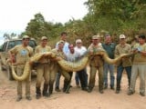
 μαλλον λενε φιδια Sτο CNN koloψευτες αμερικανοι!!! το ιδιο κα TO BBC ΦΙΔΙΑ ΦΙΔΙΑ !!!!!!
  KOLOAMERIKANAKIA !!!!!!!! ΑΚΟΥ ΛΕΕΙ ΚΗΚΛΟΦΟΡΑΝΕ με βαρκες!!!!!!!!! απα πα αφου εδω διαβασα οτι απολαμβαναν τα συντροφια της καταπληκτικες βραδυες !!! καναν και βολτες!!! ρε μαλακιες που γραφουν τα διεθνη ειδησιογραφικα δικτια!!! στανταρρρ!!!!!! απο τον ιουλειο λεει!!! !!!!!!!!!!!!! ti ginete ρε πουστη φιδια και οι δικοι μας δημοσιογραφοι ???? τορα το διαβασα αυτο!!! πουτανα παγκοσμιοποιηση!!! μπα ολοι ζηλευουν τους δικουσ μας που γαμανε ακομα
  κληνουν εισιτιρια κανουν παρτουζες και μπανια απο τον ιουλειο και μεχρι σημερα
  φιδια φιδια γραφουν οι κολοδημοσιογραφοι!!!!!!!!!!!! δεν τουσ πιστευω!!!!!!
 AAAA DEN TO PISTEYO!!!!!!400 πνιγμενους μετρανε :S :S :S απο τον ιουλιο βρεχει συνεχεια και εδω μεσα διαβαζα ταξιδαρες και γαμησια και γλεντια
το καπνιζουν και οι αλλοι !!!!!!!!!!! για βαλε KAI CNN !!!Ρε φιλε
Δεν ξερω τι καπνιζεις αλλα πρεπει να ειναι ΠΡΩΤΟ!!!
KAI ΕΣΗ ΑΠΟ ΤΗΝ ΠΑΤΑΓΙΑ ΜΑς ΓΡΑΦΕΙς ΑΔΕΡΦΕ???? βαλε και εση καμια φοτογραφια ντεε!!!!!!!! αληθινη σαν τους αλους!!!! μου ρχοντε στο μιαλο ιδεες πολεες!!!! του τυπου αεροπορηκες ετεριες πουλανε εισητηρια!!!!! συντροφοι πουλανε εκδουλευση τα παραμιθια της χαλιμας κτλ!!!! που ειναι οι αξιοσεβαστοι πολυγραφοτατοι συντροφοι του θρεντ???????????? υ.γ δεν μεμφομε κανεναν αλλα εχτες οι εικονες που εδειξε το CNN ΜΕ ΑΦΗΣΑΑΝΝΝ ΜΑΛΑΚΑΑΑΑΑΑΑΑ ΤΕΛΕΙΟς ΕΙΔΑ ΚΑΙ ΕΙΚΟΝΕς ΤΟΥ CNN ΑΠΟ ΤΟΝ ΙΟΥΛΕΙΟ ΜΕΧΡΙ ΤΟ ΣΕΠΤΕΜΒΡΙΟ ΜΕ 87 ΠΝΙΓΜΕΝΟΥΣ!!!!!!!!!!!!!!!! EPISHMA!!!!!! ΚΑΙ ΕΔΩ ΤΙΠΟΤΑ ΤΣΙΜΟΥΔΙΑ ΤΟΥΛΑΧΙΣΤΟΝ ΥΠΟΠΤΟ ΤΟ ΓΕΓΟΝΟς!!!!!!!!!!!!!!!!!!!!! SOSTOS! ΑΔΕΡΦΕ αλλα παντα αυτο το θρεντ το ειχα σε εκτημηση!!!<< και το εγραψα οτι δεν μεμφομε κανεναν!!!!!!>> και για της αναλιτικες περιγραφες και για το μετρο και για την ποιοτητα της γραφης και της περιγραφης!!!!!! αλλα υποψιαζομαι σοβαροτατα τορα οτι αυτο το θρεντ διαφερει απο τα υπολ0Ιπα ΓΙΑ ΕΥΝΟΗΤΟΥς ΛΟΓΟΥς!!! $$$ !!!! ΜΠΟΡΕΙ ΝΑ ΕΙΝΑΙ ΚΑΙ ΛΑΘΟς!! αλλα δεν μπορει να εχει γινει της πουτανας ο πνηγμος απο τον ιουλειο και μετα και εδω περα να εχει αναφερθει μονο απο ενα συντροφο οτι εβρεχε ενα βραδυ!!!!!! τελος παντον επειδη διανηουμε δησκολους καιρους ας ειμαστε ΤΟΥΛΑΧΙΣΤΟΝ ΕΠΙΦΙΛΑΚΤΙΚΟΙ!!! υ.γ το φενομενο μινα δεν πλητει μονο την ταηλανδη!! αλλα ολη την γειρω περιοχη εχουν θιματα παντου !!!! απο το βιετναμ μεχρι την μαλεσια κατο !! τι βορεια και νοτια???? ΚΑΙ 3 ΜΙΝΕς ΤΩΡΑ!!!!!!!! τελος παντον καλα εγραψε ο δημητρακις οτι θα παει ταηλανδη για να φτιαξει φιδησια ρουχα!!!!!αραξε φιλε νταβαρτις! οι ποιο πολλοι εδω μεσα πανε παταγια αντε πουκετ, και εκει δεν υπηρχαν τετοια προβληματα ολα αυτα που βλεπεις στις ειδησεις εχουν συμβει απο βορεια προαστεια της μπανγκοκ και πανω κατα μηκος του κεντρικου ποταμου, και η κατασταση ολο και χειροτερευει ευτηχως η περιοδος των βροχων τελειωνει, τωρα για το οτι γραφονται και πολλα "φιδια" εδω μεσα καμια αντιρηση, οπως και οτι χαρακτηρηζουν μια χωρα και ενα λαο, ακομα και το χαρακτηρα των ανθρωπων, σε σχεση με το τη ειδαν στη μονο στη παταγια, σαν να πας μονο στα μαλλια στη κρητη και να βγαλεις συμπερασμα για ολους τους ελληνες
 ο τσαρος ολαααα τα ξερη!!!!!! Υ.Γ ΕΝΤΗΠΟΣΗ ΜΟΥ ΚΑΝΕΙ ΤΟ ΓΕΓΟΝΟς οτι κανεις απο τους ειδηκους δεν μιλαει με σκαυπ με κανα μορο απο εκει>>>??? τουλαχιστον να εγραφε τι ακριβος γινετε!!!! εγω πχ αμα κλασει ο προεδρος στην ουκρανια το μαθενο αμεσος απο της καργιολες μου μεσο σκαυπ!!!!! δεν μπορει οι τοσο ενημερομενοι γραφοντες εδω να μην εχουν τετοιες επαφες μεσο σκαυπ μουγκα ομος!!!! βρομαει το πραγμα απο παντου!!!!!!! δυστηχος!!!!!
φειλε εχοις απωλυτο δοικειο,δειστοιχοσ μασ ανακκαλιψεσ!!!!!εγο ιμε εκπροσοποσ τησTHAI κε ιθελιμαινα πρωσπαθουσα να προοθισο ισιτιρεια για εκεινα τα μερη,ι αλιθια ειναι οτι ι πνιγνενι δεν ιναι μονο 400 αλα 400000,το καλωκερι δε σοθ κριβω οτει ενα μινα κατο ιχα σαν δαιυτερι δουλια τι σιλογοι τον πνιγμενον(καλα λεφτα).τορα οσο για τα φειδια δε σου κριβο οτι κανουν καταπλικτικο σεξ(θαιλι λιγι πρωσπαθεια αλα βρισκισ ακρει),τι τελευεα εβδομαδα αιμεινα με μια ωχεια τρελο μορο αλλα επινε πολι ι πουταναSOSTOS! ΑΔΕΡΦΕ αλλα παντα αυτο το θρεντ το ειχα σε εκτημηση!!!<< και το εγραψα οτι δεν μεμφομε κανεναν!!!!!!>> και για της αναλιτικες περιγραφες και για το μετρο και για την ποιοτητα της γραφης και της περιγραφης!!!!!! αλλα υποψιαζομαι σοβαροτατα τορα οτι αυτο το θρεντ διαφερει απο τα υπολ0Ιπα ΓΙΑ ΕΥΝΟΗΤΟΥς ΛΟΓΟΥς!!! $$$ !!!! ΜΠΟΡΕΙ ΝΑ ΕΙΝΑΙ ΚΑΙ ΛΑΘΟς!! αλλα δεν μπορει να εχει γινει της πουτανας ο πνηγμος απο τον ιουλειο και μετα και εδω περα να εχει αναφερθει μονο απο ενα συντροφο οτι εβρεχε ενα βραδυ!!!!!! τελος παντον επειδη διανηουμε δησκολους καιρους ας ειμαστε ΤΟΥΛΑΧΙΣΤΟΝ ΕΠΙΦΙΛΑΚΤΙΚΟΙ!!! υ.γ το φενομενο μινα δεν πλητει μονο την ταηλανδη!! αλλα ολη την γειρω περιοχη εχουν θιματα παντου !!!! απο το βιετναμ μεχρι την μαλεσια κατο !! τι βορεια και νοτια???? ΚΑΙ 3 ΜΙΝΕς ΤΩΡΑ!!!!!!!! τελος παντον καλα εγραψε ο δημητρακις οτι θα παει ταηλανδη για να φτιαξει φιδησια ρουχα!!!!!
Αχαχαχαχαχαχαχαχαχαχαχαχαχα!!!!!φειλε εχοις απωλυτο δοικειο,δειστοιχοσ μασ ανακκαλιψεσ!!!!!εγο ιμε εκπροσοποσ τησTHAI κε ιθελιμαινα πρωσπαθουσα να προοθισο ισιτιρεια για εκεινα τα μερη,ι αλιθια ειναι οτι ι πνιγνενι δεν ιναι μονο 400 αλα 400000,το καλωκερι δε σοθ κριβω οτει ενα μινα κατο ιχα σαν δαιυτερι δουλια τι σιλογοι τον πνιγμενον(καλα λεφτα).τορα οσο για τα φειδια δε σου κριβο οτι κανουν καταπλικτικο σεξ(θαιλι λιγι πρωσπαθεια αλα βρισκισ ακρει),τι τελευεα εβδομαδα αιμεινα με μια ωχεια τρελο μορο αλλα επινε πολι ι πουτανα